Hi Readers,
Many thanks for all your encouragements and congratulations.
The end of the trip was both elating and a bit sad that the journey is over.
Thanks to all those that made this possible, it was a joint effort and I've put a sticker on the bike that says "We crossed the Nullarbor".
Friday, 18 November 2011
Wednesday, 16 November 2011

Day 22 Cunderdin - Chidlow 125km
Good tailwinds today. Even though the Great Eastern Highway - Route 94 - became wider and smoother, the trucks no longer moved over, especially when there was an overtaking lane. I was happy to be off that road and on the railtrail.
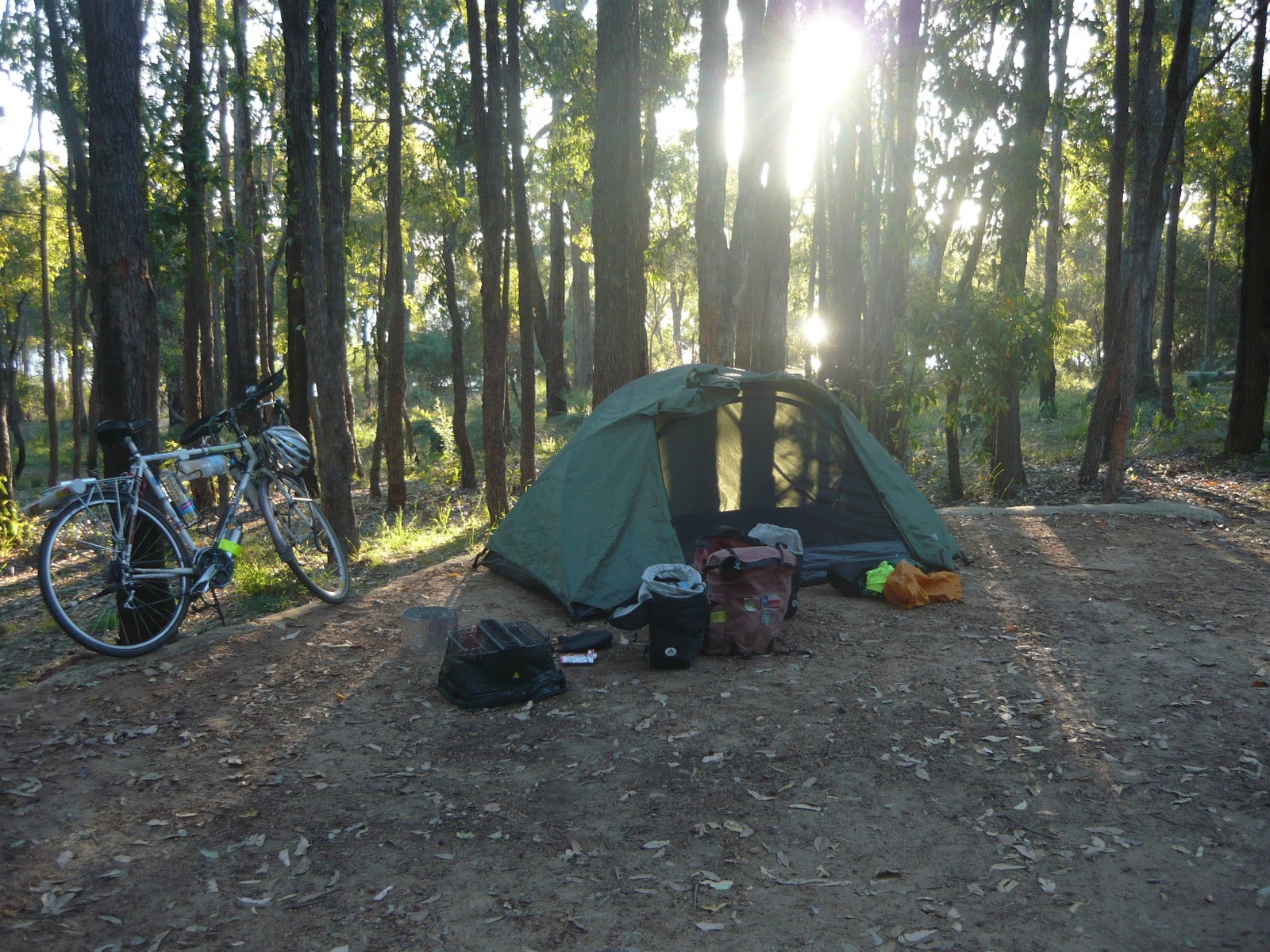
Camped near Chidlow at Lake Leschanaultia which was a beautiful place to camp.
The rail trail to Midland went through the John Forrest National Park, and was mostly downhill. It was a joy to scoot on that track than ride on the highway.
I set a new speed record of 49km/h downhill back on the highway.
 | ||
| Peter who has been on the road for seven years! (Northam) |
 | ||
| Last night of camping at Lake Leschanaultia |
Monday, 14 November 2011
Day 21 Merredin to Cunderdin 108km
Hi,
Just a short message:
Headwinds, good road - wide and smooth.
Will ride from Cunderdin to Northam (56km) , then take the Kep bike track to Woroloo , then the Rail reserves heritage trail to Midland. I'll stay in Midland on the 15th, and make the final dash to the Indian Ocean on the 16th. Barring bottles.
http://www.railtrails.org.au/states/trails.php3?action=trail&trail=49
Rob.
Sunday, 13 November 2011
Day 20 Southern Cross to Merredin 110km
This was a heavy headwind day.
Route 94 deterioated for 75km out of Southern Cross, then the shoulder widened to become a bicycle autobahn. It was a hairy ride for that 75km, and had to constantly check the mirror and over my shoulder.
It seems that the W.A. term for a cyclist is an "anchor". This is what I was called with gusto by a passenger of a passing shiny utility that had a muffler problem. I don't understand the nautical connection, but will look it up later. He may have said the Nyoongar Aboriginal phrase "gnank-aarr" which means "my voice has broken and I will soon be a man!".
In any case I responded with a friendly bird-like wave and carried on my way.
To date the bike has been faultless. Here is a list of equipment failures to date:
1. bent kick-stand from being overloaded
2. suncream impregnated riding gloves that hold their shape.
3. slightly stretched brake cable from a heavy stop.
4. slightly scorched saucepan.
5. self-deflating Thermorest (tm) mattress.
Right now I am at Kelleberrin on route to Cunderdin, the second last stop.

Remy from France

Rabbit Proof Fence near Merredin

More wildflowers

Hill near Norseman
Saturday, 12 November 2011
Day 19 Bush camp 4 (beyond Coolgardie) to Southern Cross 140km
The last two days have been getting hotter. Today it was about 30degrees.
Southern Cross marks the boundary from mining country to the wheat belt.
The last two days brought good tail winds, so I managed to gain a day.
The camera's memory stick to USB adaptor can't physically fit in the PC here, so I can't add photos to this entry. Pity, because there are many different types of wild flowers that I've photographed along the road side. Maybe I could add them tomorrow.
Route 94 isn't very suited for bicycles. The shoulder, if it exists, is too narrow and bumpy. The edge of the asphalt has a 5cm drop to the gravel. The gravel is bauxite, which is like riding on ball bearings. So, if any other cyclists are reading this blog for information on a suitable route - avoid 94. I've had a near slip and fall but was able to stop falling over.
Next stop is Merredin, but if the wind is good I may go further.
Thursday, 10 November 2011
Day 18 Widgiemooltha to Coolgardie and beyond 125km
Hi All,
I have mixed up all the days and have just corrected them all.
Had a poor night sleep. The camping ground at Widgiemooltha was 50m from the loudest generator, underneath a light and about 20m from the highway. I turned off the light, but the owner came down an hour later and switched it on again.
I had an easy 76km ride to Coolgardie, most of it seemed to be downhill.
It's so good to be in a place where the buildings are made of brick and not tin or fibro cement. And there's an IGA! Whoo - civilization.
I forgot to mention the longest golf course in the world; the 1365km long Nullarbor links golf course. http://www.nullarborlinks.com/.
The road from Norseman to Coolgardie took a lot more concentration to ride since it is narrower, hillier and winds its way North. I had to pull over on the side many times when I could hear a truck coming. Also, the traffic is increasing. The trucks are gargantuan and carry gargantuan machinery that digs, drills and levels mountains. Most cars here have an orange light on their roof and most people wear fluoro vests. Yes - I'm in mining country.
Never mention taxing what's in the ground that rightfully belongs to China, or you'll be in for a fight!
The next link in the riding chain Westwards is the Boondi campgrounds 90km from here , then Southern Cross 100km further. I'm not sure if I'll make the campgrounds, but will see how far I can go in the next 4 hours.
At this rate I should be in Perth late on Nov 17.

Wildflowers

Postcard from Cocklebidy.
Wednesday, 9 November 2011
Day 16 Fraser Range to Norseman 100km
After some very tiring days battling 20 knot headwinds , er gales, I've officially crossed the Nullarbor and am Norseman.
Today was a pretty good ride. Yesterday it took 10.5 hours to ride 90km. At times the bike was in the lowest gear, and was going at 7km/hour, even on down hill sections. I walked about 3km up some hills.
Fraser Range Station is a wonderful gem of a place to stay. If you're ever crossing the 'bor, it's well worth the stay. Very historic and picturesce surroundings.
I won't publish any photos tonight since this caravan park PC keeps bleating about illegal applications. I don't wont to have the memory stick erased! Will try in town tomorrow.
Today I finally met the mysterious cycling pair who have been one day ahead of me. They were taking a rest day before heading off to Esperance. Everyone I've met who was heading East kept mentioning them.
From Noresman there are three ways to Perth:
1. Scenic and hill route to Esperance then Albany then up the South West coast. This is the way that most cyclists take. I won't be because its an extra 4 days to Perth.
2. The 'industrial' way to Coolgardie then down Highway 94. I'll be going this way.
3. Woodlands trail to Wave Rock and Hyden. This saves a day, but it is a track and you need to camp for two nights.
Ok, I'm going to check if the washing machine here has choked on the dusty clothes I put in, then see about the reported famous pizza in town.
Maybe photos tomorrow.
Next destination: Widgiemooltha 94km away.
Thanks for your comments again.
Tuesday, 8 November 2011
Day 15 Fraser Range to Norseman
Rob hopes to have internet access tonight so he can update the last couple of days.
Saturday, 5 November 2011
Day 13 Cocklebiddy - beyond Caiguna - to Bush Camp #3, 121km
Just a short break after a 63km ride to Caiguna. From here its 183km to the next roadhouse, Balladonia. If the winds are good, then I could be there in 2 days, ie Monday night. But if the wind is a headwind, I'll have to bush camp twice and should be at Balladonia Tuesday morning. So, I could be out of contact for the next 2 days.
 This is the thanks I get for trying to shoo him off the road.

Day 12 Madura to Cocklebiddy 93km
A much easier ride today. I can almost smell the Indian Ocean from here.
There was some mice in the room last night. I put double sided tape around the bike wheels so they couldn't climb up the bike and into the panniers.
There was about 60km of head wind today. The wind changed to be a side/tail wind that made the last 33km easier.
The country side was more or less uninteresting. Flat, a few trees.
Road kill count includes: camel, wedge tailed eagle, echidna, wombats, lizards, owls, mice, and hundreds of kangaroos.
The internet connection here is best since Ceduna. The computer at Madura had 51 instances of Internet Explorer opened. It was way too slow to add pictures.


 Dawn at bush camp #1, between Nundroo and Yalata.
 The road goes forever. That's not a crosswalk painted, but a road landing strip for the Royal Flying Doctor Service.
Next stop will be a bush camp to the West of Caiguna on the 90 mile straight. I'll add an update at Caiguna if they have Internet.
There was some mice in the room last night. I put double sided tape around the bike wheels so they couldn't climb up the bike and into the panniers.
There was about 60km of head wind today. The wind changed to be a side/tail wind that made the last 33km easier.
The country side was more or less uninteresting. Flat, a few trees.
Road kill count includes: camel, wedge tailed eagle, echidna, wombats, lizards, owls, mice, and hundreds of kangaroos.
The internet connection here is best since Ceduna. The computer at Madura had 51 instances of Internet Explorer opened. It was way too slow to add pictures.

Bunda Cliffs

Old Telegraph station. It must have been a hard life for the telegraphists in 1877, but at least they were on-line.


Just outside Yalata


Next stop will be a bush camp to the West of Caiguna on the 90 mile straight. I'll add an update at Caiguna if they have Internet.
Friday, 4 November 2011
Day 11 Mundrabilla - Madura 118km
To quote Banjo Patterson's poem, Mulga Bill's bicycle:
" I've rode a bull around a yard to win a five pound bet,
but that was the most awful ride that I've encountered yet".
Phew, 118km of relentless headwind and rain. This after a dream run of at least 5 days of tailwinds.
Just rolled into Madura -the half way point! Unfortunately the speedometer glitched a few days ago, and lost its accumulated km. Anyway, the sign here says that Pt Augusta is 1144km behind.
The parcel of food is here, and luckily the mice plague around this area has spared it.
Not staying in a tent tonight, booked a budget room and will soon be going to the room. There are some thunderstorms expected tonight.
The road trains just keep getting bigger. Some look like they are carrying large sections of an Aircraft-carrier! I spoke to a driver at Mudrabilla last night. He said that they are in constant radio contact with each other, and know well in advance when a cyclist is ahead, so they give plenty of room.
The traffic has thinned out, and the cars and trucks are about 10 minutes apart.
Unfortunately there is lots and lots of roadkill. There is a reported camel near Madura.
I haven't swatted any blowflies - they are too quick.
Here is a photo of me taken by Hugh and Pauline when we met at Penong:
http://www.crazyguyonabike.com/doc/page/?o=1r4vFZo&page_id=265728&v=3Z
I'll add some photos tomorrow morning and more reports.
(Postscript - unable to add photos)
Wednesday, 2 November 2011
Day 10 (Thurs 3rd Nov) - Bunda Cliffs Bush camp to Mundrabilla, 130km
Rob had more tailwinds. He went through Border Village & Eucla - visited Eucla Telegraph Station. No internet access at Eucla or Mundrabilla. Expecting tailwinds tomorrow and will pick up food parcel.
Tuesday, 1 November 2011
Day 9 (Wed 2nd Nov) - Nullaboor Roadhouse to bush camp along the Bunda Cliffs, 150km.
Rob started the day with tailwinds.He met a French cyclist who was riding the opposite way. He had done 60km battling headwinds to Rob's 130km. Bike stand has broken.
Day 8 (Tues 1st Nov) - Bush camp to Nullaboor Roadhouse
Update from Rob (he doesn't have any internet access) - 120km ride, flat, treeless, the real Nullaboor. More tailwinds! Thermarest is leaking.
Subscribe to:
Posts (Atom)